Anybody have Luftwaffe airfield maps or aerial pics?
Results 1 to 15 of 15

Thread: Anybody have Luftwaffe airfield maps or aerial pics?

  1. #1

    Anybody have Luftwaffe airfield maps or aerial pics?

    Hi All

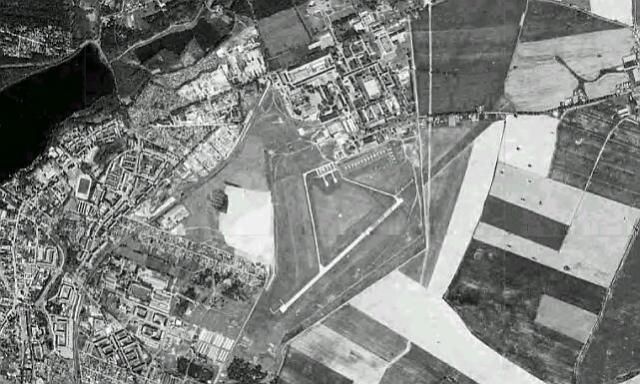
    I am getting started on a new historical campaign featuring I/JG11 in WWII (equipped with Focke Wulf 190s). They had 23 different airbases from 1943 to 1945. I need 16 of them for the campaign. Achim had done 4 of them, and so far, I have completed another 5. The problem is finding any graphical information about them. I have one more, Gelnhausen, that I have aerial pics and a map for. After that there are 7 that I am without any references. I think I have exhausted the web.

    Can anyone help?

    The airfields I need references for are:

    Wiesbaden-Erbenheim
    Dedelstorf
    Stausberg
    Berlin-Gatow
    Larz
    Neustadt-Glewe
    Leck

    Thanks in advance
    Cheers,

    Captain Kurt
    ------------------------------------------------------
    "Fly, you fools!" Gandalf the Gray

  2. #2
    Kurt,

    nothing on Stausberg or Larz. For the other ones check your email.

    Cheers

    Achim

  3. #3
    Hi Achim,

    It's good to hear from you, I hope you are doing OK.

    This will be for the Luftwaffe campaign development campaign I promised to you.

    Thank you for your response but I haven't gotten any email from you yet. Would you please check and re-send?

    By the way I misspelled Strausberg, I dropped the R for some reason.
    Cheers,

    Captain Kurt
    ------------------------------------------------------
    "Fly, you fools!" Gandalf the Gray

  4. #4
    Kurt,

    maybe I got your email address wrong, but that is the only one I have.
    To make it work, please, send me an emaill.

    Check your pm.

    Cheers


    Achim

  5. #5
    Hi Achim

    You have the correct email address. I just sent you an email you can reply to.
    Cheers,

    Captain Kurt
    ------------------------------------------------------
    "Fly, you fools!" Gandalf the Gray

  6. #6
    There is a whole book with german base maps available, a collection of sketches by the allies done in the last days/after the war.

    The ISBN is 3-613-01486-6 - it is quite rare of course and thus a bit expensive. With some luck, you can find it on ebay for 50-100,- Euros.

    I sent Achim some scans some time ago, and I think these are the maps, you have now.

    For Larz, see Rechlin-Laerz:

    http://en.wikipedia.org/wiki/Rechlin...%A4rz_Airfield
    Visit my CFS2-dedicated sites: CFS2 : Tips&Tricks + Downloads + A/C-Profiles + Links

  7. #7

    Capt...

    ...so far haven't found any actual pics but did find this reference that gives descriptions of WW2 Luft. fields in WW2. But maybe you have already seen this link.
    http://www.ww2.dk/Airfields%20-%20Ge...Borders%5D.pdf

  8. #8
    Tiller of Soil MaskRider's Avatar
    Join Date
    Jun 2005
    Location
    Alpine, CA in San Diego's beautiful back country!
    Age
    72
    Posts
    2,228

    Icon22

    Many of these old airfield locations can also be found using GoogleEarth. Especially when you know the general location and if the area hasn't been built up too much since the time of their use- probably much more likely in the PTO than in the ETO. But you never know. The tell tale signs of disturbed earth remain behind for a long time. Lots of long abandoned, 60+ years abandoned, WWII PTO airfields are still very much visible using GoogleEarth. Many times the runways, taxiways and aprons have been incorporated into the surrounding urban design and are still quite easy to pick-out.

    The research on these old fields is always a good deal of the fun in making the scenery.

    Good luck!
    MR
    "A sandwich and a cup of coffee, and then off to violin-land, where all is sweetness and delicacy and harmony, and there are no red-headed clients to vex us with their conundrums.”

    ― Sherlock Holmes


    MR Downloads at SOH
    MR Albums at SOH MR Web Site

  9. #9

    Just found this.......

    ...from a previous inquiry made at another forum. Might be something you can use.
    Ack, Misread the name ! It is Grove not Gatow! Anyway here it is.
    http://www.gyges.dk/fliegerhorst_grove%20intro.htm


  10. #10
    Hi guys

    Thanks all.

    Jaxon, Achim was able to find the WWII British map of Rechlin-Larz so I can cross that one off the list. I hadn't heard of the book so I will search for it - thanks.

    Fibber thank you for the effort. Yes I do have the reference you mention. In fact the author has a number of these description documents for Luftwaffe fields in other occupied European counties too. Unfortunately, it's all descriptions with no maps or images included, so it is of limited airfield building value but it provides location and some cross referencing of details. In the case of Luftwaffe temporary fields just using farming fields it is the only reference there is that I know of.

    Maskrider, Google Earth is our friend in the PTO for sure. It is much more limited in Europe as there has been extensive development since the war. In some cases the airfields still exist but were redeveloped for handling jets and not much is left of the original Fliegerhorst. There are hints in some cases so it helps some. It looks like Strausberg will wind up with this method as nothing on the original field seems to be turning up.

    Thanks all. If anything turns up please let me know
    Cheers,

    Captain Kurt
    ------------------------------------------------------
    "Fly, you fools!" Gandalf the Gray

  11. #11
    CK,

    Location & bare bones description of Straussberg at Axis History forum. Described as a grass runway...

    http://forum.axishistory.com/viewtopic.php?t=155355

  12. #12
    Here's for strausberg kurt still in b&w pic ...hope this's what u looking


    STRAUSBERG RWY
    • (172/352) 660m x 30m G
    • (049/229) 1200m x 40m G
    • (049/229) 1200m x 28m

  13. #13
    Thank you - it is the type of photo I am looking for.

    However this is a modern photo, not WWII. During WWII the airfield had only a grass surface field with no paved runways.
    Cheers,

    Captain Kurt
    ------------------------------------------------------
    "Fly, you fools!" Gandalf the Gray

  14. #14
    is that part of the old field. the area to the right. it looks like RR Tracks going across it.

    Here is something interesting

    http://www.ww2.dk/Airfields%20-%20Denmark.pdf


    Strausberg historical info...
    http://www.flugplatz-strausberg.de/?nv=sub1&lang=en


    Information available E-Mail: info(at)flugplatz-strausberg.de .


    Extra info...
    http://www.ww2.dk/air/jagd/jg11.htm
    http://forum.axishistory.com/viewtopic.php?t=155355

    sorry its the same as above...


    Last edited by Blood_Hawk23; January 31st, 2015 at 18:23.
    "Courage is the discovery that you may not win, and trying when you know you can lose."-Tom Krause

    My works Here: http://www.thefreeflightsite.com/JFortin.htm

  15. #15
    "Courage is the discovery that you may not win, and trying when you know you can lose."-Tom Krause

    My works Here: http://www.thefreeflightsite.com/JFortin.htm

Members who have read this thread: 1

Bookmarks

Posting Permissions

  • You may not post new threads
  • You may not post replies
  • You may not post attachments
  • You may not edit your posts
  •